Detail View: SHIMMER: Wath Headlands Parish Map
|
Title:
|
Wath Headlands Parish Map
|
|
Creation Date:
|
1997
|
|
Image Date:
|
2002
|
|
Period:
|
20th century
|
|
Location:
|
Wath-upon-Dearne, South Yorkshire
|
|
Country:
|
ENGLAND, UK
|
|
Material:
|
iron - cast, steel , limestone - black Kilkenny , concrete - coloured
|
|
Display Creator:
|
BRAILSFORD, Victoria and David MAYNE
|
|
Image ID:
|
r006
|
|
Description:
|
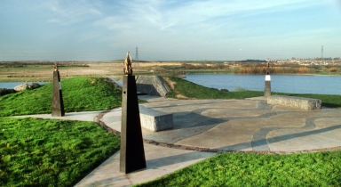
Location: On the Headland which protrudes into the lake north of Wath Manvers, Wath-upon-Dearne, South Yorkshire. Google maps < https://goo.gl/maps/bTLF0 > .
Description: A number of co-related artworks were sited on the Headland. At the entrance to the site was Vic BRAILSFORD's 'Stone columns'. Two square pillars made up of layers of different stone whose thickness corresponds to the geological strata under the site. These have subsequently been vandalised. At the far end of the site are two laser-cut stainless steel maps: these were cut, stencil-fashion, into stainless steel plate. One shows a cross section of the rock, coal seams, shafts etc for Wath Main Colliery; the other shows a map from c.1930 (containing railway sidings etc) and also one from c.1997 of the site. The artists had a cutting made through the prominent mound at the end of the Headland. The sides of the cutting were clad in black limestone; a reference to coal and to mining. The maps were bolted onto the sides of the cutting. They have subsequently been vandalised. On the landward side of the above is a flat circular area containing four elements: Inscriptions: A stainless steel plaque on site records the following information: Commission: Funded by English Partnerships, the Dearne Valley Partnership, Yorkshire & Humberside / Arts and Rotherham Borough Council. Joint commission. £73,000. [2] The artwork was formally unveiled on 23 October 1997 by Cllr. Gerald Smith, Mayor of Rotherham, and Cllr. Brian Walker, Chair of the Economic Development Committee, Rotherham MBC. Comment: This project, involving an enormous amount of contact with the local community, and considerable research, promised to produce artworks of considerable stature and permanence. Sadly they have been a prey to vandalism from the moment they first appeared. The artists even had to hire a security firm to mount guard over the site at night while this work was being installed. [3] The partial destruction of this work is shameful. Brailsford and Mayne had produced artworks of quiet stature which told the history of the site in a number of elegant and restrained ways, and which, in part through the considerable local involvement in their manufacture, had gained substantial support from many in the community. A former miner from Manvers Pit, who was walking his dog on the site while this survey was carried out, was visibly upset to see recent damage to the map of the pit. He believed that this damage was the work of a very small group of children living in the area. [4] References: [1] Conversation with David Mayne (23/3/2003) |
|
Rights:
|
© Sheffield Hallam University
|
|
Permissions:
|
For educational use only. This image may be used in print or digital materials provided that full acknowledgment is given, expressed as follows: " © < insert details from the 'Rights' field >. Photographed by < insert details from the 'Photographed by' field >."
|
|
Photographed by:
|
Dave Ball
|
|
Creator:
|
BRAILSFORD, Victoria
|
|
Creator Role:
|
Sculptor.
|
|
Culture Gender:
|
Female.
|
|
Nationality:
|
British.
|
|
Creator:
|
MAYNE, David
|
|
Creator Role:
|
Sculptor. Ex-student at Sheffield Hallam University.
|
|
Culture Gender:
|
Male.
|
|
Nationality:
|
British.
|
|
Subject Heading:
|
Public art -- England (South Yorkshire)
|
|
Subject Heading:
|
Sculpture -- 1900-2000
|
|
Subject Heading:
|
Monuments -- England (South Yorkshire)
|
|
Subject Heading:
|
Maps in art
|
|
Subject Heading:
|
Heritage tourism -- England (South Yorkshire)
|
|
Subject Heading:
|
Rural renewal -- England (South Yorkshire)
|
|
Subject Heading:
|
Parks -- England (South Yorkshire)
|
|
Subject Heading:
|
Landscape design -- England (South Yorkshire)
|
|
Subject Heading:
|
Reclamation of land
|
|
CharacterSet:
|
%G
|
|
RecordVersion:
|
1
|
|
History[2]/stEvt:action:
|
saved
|
|
AlreadyApplied:
|
True
|
|
History[2]/stEvt:changed:
|
/
|
|
Marked:
|
False
|
|
History[1]/stEvt:softwareAgent:
|
Adobe Photoshop CS5 Windows
|
|
ModifyDate:
|
2015-02-17T15:09:18Z
|
|
History[1]/stEvt:when:
|
2015-02-17T15:09:18Z
|
|
History[2]/stEvt:softwareAgent:
|
Adobe Photoshop CS5 Windows
|
|
OriginalDocumentID:
|
xmp.did:0859768AB5B6E411A0BDFEA2293A8937
|
|
History[2]/stEvt:when:
|
2015-02-17T15:09:18Z
|
|
History[1]/stEvt:action:
|
saved
|
|
History[1]/stEvt:instanceID:
|
xmp.iid:0859768AB5B6E411A0BDFEA2293A8937
|
|
ICCProfile:
|
sRGB IEC61966-2.1
|
|
History[1]:
|
type=Struct
|
|
History[1]/stEvt:changed:
|
/
|
|
History[2]:
|
type=Struct
|
|
CreateDate:
|
2007-07-16T18:28:57+01:00
|
|
History:
|
type=Seq
|
|
format:
|
image/jpeg
|
|
DocumentID:
|
xmp.did:0859768AB5B6E411A0BDFEA2293A8937
|
|
ColorMode:
|
3
|
|
MetadataDate:
|
2015-02-17T15:09:18Z
|
|
InstanceID:
|
xmp.iid:0959768AB5B6E411A0BDFEA2293A8937
|
|
History[2]/stEvt:instanceID:
|
xmp.iid:0959768AB5B6E411A0BDFEA2293A8937
|