Detail View: SHIMMER: Doncaster Borough Map
|
Title:
|
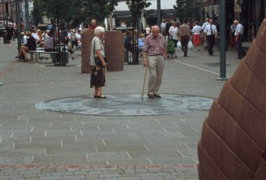
Doncaster Borough Map
|
|
Creation Date:
|
1999
|
|
Image Date:
|
1999
|
|
Period:
|
20th century
|
|
Location:
|
Doncaster, South Yorkshire
|
|
Country:
|
ENGLAND, UK
|
|
Material:
|
gritstone
|
|
Display Creator:
|
BRAILSFORD , FALLAIS
|
|
Image ID:
|
99-2749
|
|
Description:
|
Location: Frenchgate. View looking past one of Brailsford's 'Vessel's' to the Map of Doncaster by Fallais with onlookers. Part of Phase 3 of Doncaster Metropolitan Borough Council 'Quality Streets Project' (1998-1999). The project is part-financed by the European Community and by the Government's Challenge Fund through the Single Regeneration Budget.
|
|
Rights:
|
© Sheffield Hallam University
|
|
Permissions:
|
For educational use only. This image may be used in print or digital materials provided that full acknowledgment is given, expressed as follows: " © < insert details from the 'Rights' field >. Photographed by < insert details from the 'Photographed by' field >."
|
|
Image Storage Location:
|
http://helios.shu.ac.uk/99-2749.tif
|
|
Photographed by:
|
Dave Ball
|
|
Creator:
|
FALLAIS, Lesley
|
|
Creator Role:
|
Artist.
|
|
Culture Gender:
|
Female.
|
|
Nationality:
|
British.
|
|
Creator:
|
BRAILSFORD, Victoria
|
|
Creator Role:
|
Sculptor.
|
|
Culture Gender:
|
Female.
|
|
Nationality:
|
British.
|
|
Subject Heading:
|
Public art -- England -- Doncaster
|
|
Subject Heading:
|
Pedestrians
|
|
Subject Heading:
|
Shopping -- England (South Yorkshire)
|
|
Subject Heading:
|
Urban renewal -- England (South Yorkshire)
|
|
Subject Heading:
|
Shoppers
|
|
Subject Heading:
|
Streetscapes (Urban design) -- England -- (South Yorkshire)
|
|
Subject Heading:
|
Heritage tourism -- England (South Yorkshire)
|